The Sacramento Riverfront Master plan approved in 2003 was an ambitious effort involving hundreds of Sacramento and West Sacramento residents. We dreamed, schemed and planned the future of the Sacramento River waterfront.
It was a model of citizen participation with a lot of good elements. We had joint meetings with both city councils, a historic cooperative effort, and we approved the same plan. Both cities made progress, including Embassy Suites, the Water Intake Structure and Matsui Park on our side. But Sacramento’s progress stalled in the last decade, due to the recession and other priorities.
The Docks Specific Plan, for the area south of Tower Bridge, approved in 2009, was to be a mix of 1,000 housing units, 200,000 square feet of office and retail along with lots of parking and a limited amount of park space.
I now believe we erred on the side of too much private development and not enough public uses. The plan is too intense and park space is too small. We now recognize what a special and limited space we have on the river. And there’s a public demand to “develop” the waterfront. The delays have given a second chance to create an exciting urban river park as a true public space to serve all of us.
We’ve always been a city that likes events and gatherings, but we’ve grown beyond Old Sacramento and Southside Park. We now have food trucks, a more active art scene, a more dynamic city with a strong demand for downtown living. And we have progress on the West Sacramento riverfront to consider. I believe we need to dedicate most, if not all, of the Sacramento riverfront not yet developed to public uses. Sacramento needs more places to come together, to interact and to play.
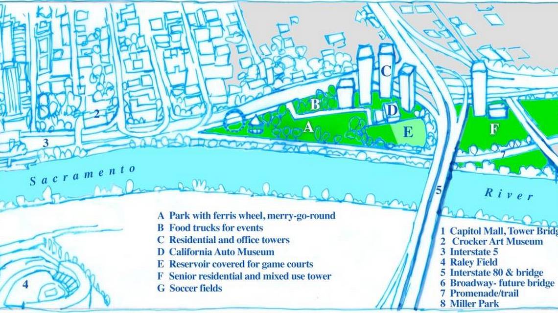
Imagine a Ferris wheel facing north toward Tower Bridge, with a merry-go-round nearby and an ice cream truck, a sweeping lawn toward the river and stairs to take you to the river’s edge to watch boats, birds, people, nature and sunsets. Food trucks and vendors could populate the area without time limits. Artists and booksellers could set up sales areas. Street musicians could serenade visitors. Events along the river could connect to Old Sacramento, the Crocker Museum, Capitol Mall and West Sacramento’s River Walk. Downtown employees, residents and tourists could stroll, joining families and friends who biked in from the Sacramento and American River Parkway trails.
The Broadway Bridge, coupled with the Tower Bridge, and walkways on both sides of the river will create “the Loop,” connecting the two river cities with a true destination and incredible site for walks and runs.
A redone and permanent Automobile Museum would anchor the south end, and the future Science and Space Museum would anchor the north, connected by an extended promenade.
South of Pioneer Bridge lies Miller Park, where visitors picnic, enjoy the shade, and fish on the banks of the river. Sooner rather than later the oil storage tanks on both sides of the river should be moved to the Port in West Sacramento, as we envisioned. They are from a time when the river was industrial. We see the river differently now: as a public amenity, a gathering place and a parkway.
Let’s choose fun. Let’s plan for nature and romance. Let’s develop our riverfront to be shared by all of us. And let’s involve the community again in revising our plans.


